


Les Etilleux 8

togolo28
User
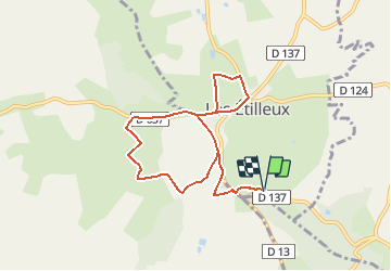

Length
7.9 km

Max alt
266 m

Uphill gradient
153 m
Km-Effort
10 km

Min alt
190 m

Downhill gradient
154 m
Boucle
Yes
Creation date :
2016-10-04 00:00:00.0
Updated on :
2016-10-04 00:00:00.0
2h09
Difficulty : Easy

FREE GPS app for hiking
 SityTrail
IGN / Geographical institutes
SityTrail Plus
The world is yours!
About
Trail Walking of 7.9 km to be discovered at Centre-Loire Valley, Eure-et-Loir, Les Étilleux. This trail is proposed by togolo28.
Positioning
Country:
France
Region :
Centre-Loire Valley
Department/Province :
Eure-et-Loir
Municipality :
Les Étilleux
Location:
Unknown
Start:(Dec)
Start:(UTM)
338497 ; 5343517 (31U) N.
Comments